Yellowknife

We left the Sambaa Deh Falls campground and continued eastward across the Mackenzie Highway, to where we would make a turn due north on the last leg of our trek to Yellowknife. We only had 56 more miles of gravel then we would get back onto paved roads – finally. We were so paranoid about breaking another spring (we had used up our very last one) that we drove only 35 mph. Our plan was to buy another spare spring – maybe 2 – when we got to Yellowknife.

We came to a small clearing along this gravel stretch of road. There was a tiny cabin there so we stopped to walk the dog and check the springs for the forty-eleventh time and look over the cute little cabin.

emer shelter

Inside, we saw a sign stating that this was an emergency shelter in case you broke down in the winter going across on your snowmobile, dog sled, or whatever. Anyone was welcome to use it until they could get help somehow. It was stocked with firewood out back and had a wood stove inside.

emer inside

Isn’t it cute? It was not uncommon to find these along the lesser-traveled roads in the far north. They were lifesavers for people who used them. You would be on your own for building a fire, eg, matches, or whatever you would use. All travelers in the far north carry emergency kits with those kinds of things in them whenever the go anywhere. You could be stuck somewhere for days depending on which road you were on if you broke down and what the weather was like.

We finally made it to where we turned north onto Highway 3 which ended at a native village called Rae. From there we turned due east onto Highway 4 which went to Yellowknife. Sadly, this last stretch of road to Yellowknife was gravel. Sigh.

Along Highway 3, we passed through a large Wood Buffalo preserve. Wood Buffalo are quite different from the buffalo found in the northern United States. They are MUCH larger and woolier and are a dark brown color.

wood bison sign

This sign alerted us to watch for the buffalo. When we finally came to some grazing along the sides of the road, we were absolutely awestruck. To say they were huge is an understatement.

wood bison1

I am not kidding you or exaggerating when I tell you that this animal was the size of our Ford F-350 crew cab truck! It was scary huge. We saw several of these tremendous creatures along the road sides – including some females with calves. The calves were the size of fully-grown Texas steers! Even the females were almost as big as our truck. These were a thrilling sight to see. We also saw some sandhill cranes but they were not in good places to get any photos. We saw moose, too.

wood bison herd

We passed through the native villages of Edzo and Rae and began making our way across the final stretch of the gravel road to Yellowknife. Yellowknife is the capital of the Northwest territories and at the time we were there, it had a population of about 19,000. The city is build on and around massive chunks of pre-Cambrian rock – the oldest exposed rock on our planet. There are only a few places on our globe that have large areas of this exposed, ancient rock. There were lots of large, pink quartz-like intrusions of rock folded into the darker basalt. They looked like meandering trails. We had never seen anything like this type of geology in all of our travels.

basalt with intrusion

yellowknife sign

The houses and buildings in Yellowknife are some very strange shapes and sizes because of having to be fitted into the basalt terrain. It would be pointless to try to move or alter any of this massive rock, so people just build on and around it. There is very little flat, level ground around town and what there is, was used up for government and office buildings in the downtown area and out at the airport. There were many house trailers. We looked around at housing prices and found that a trailer in a trailer park sold for $100,000 and up, and a stick-built house started at $250,000 for a very small one. Remember that this was back in 1999 when the only place you saw housing prices like that was in California!

They had a novel sewer and water system. All the properties had a large sewer connection pipe out at the street with a dump valve just outside their house or business.

sewer drain

Periodically, a large sewer truck would come by and hook up to the this pipe and activate your sewer dump valve and your sewage would empty into the truck. He’d close everything back down and drive to the next property’s valve. When his truck was full, he’d take it to the sewage treatment plant and empty his truck. Then he’d go back and continue on his route. He’d come by a couple times a week to dump your sewage.

It was a similar sort of set up for water service. People had a water pipe out by the street and a fresh water truck would come by a couple times per week and fill up the cistern in your residence or business. Since the ground is all solid rock, all the utilities have to be aboveground. It was a similar kind of system over in Inuvik – only over there, the problem was mostly because of the permafrost as well as some rock. There are no basements anywhere in town as this pre-Cambrian shield basalt allows for no digging. Yellowknife sits right on the northern shore of the Great Slave Lake which is the deepest lake on the North American continent at over 2000 feet deep – even deeper that Lake Superior. The water is crystal clear and icy cold.

We had lunch at the famous Wildcat Cafe, a tiny restored original building/cabin. We feasted on Carrot Ginger Soup, Arctic Char Chowder, and Musk Ox sandwiches.

wild cat cafe

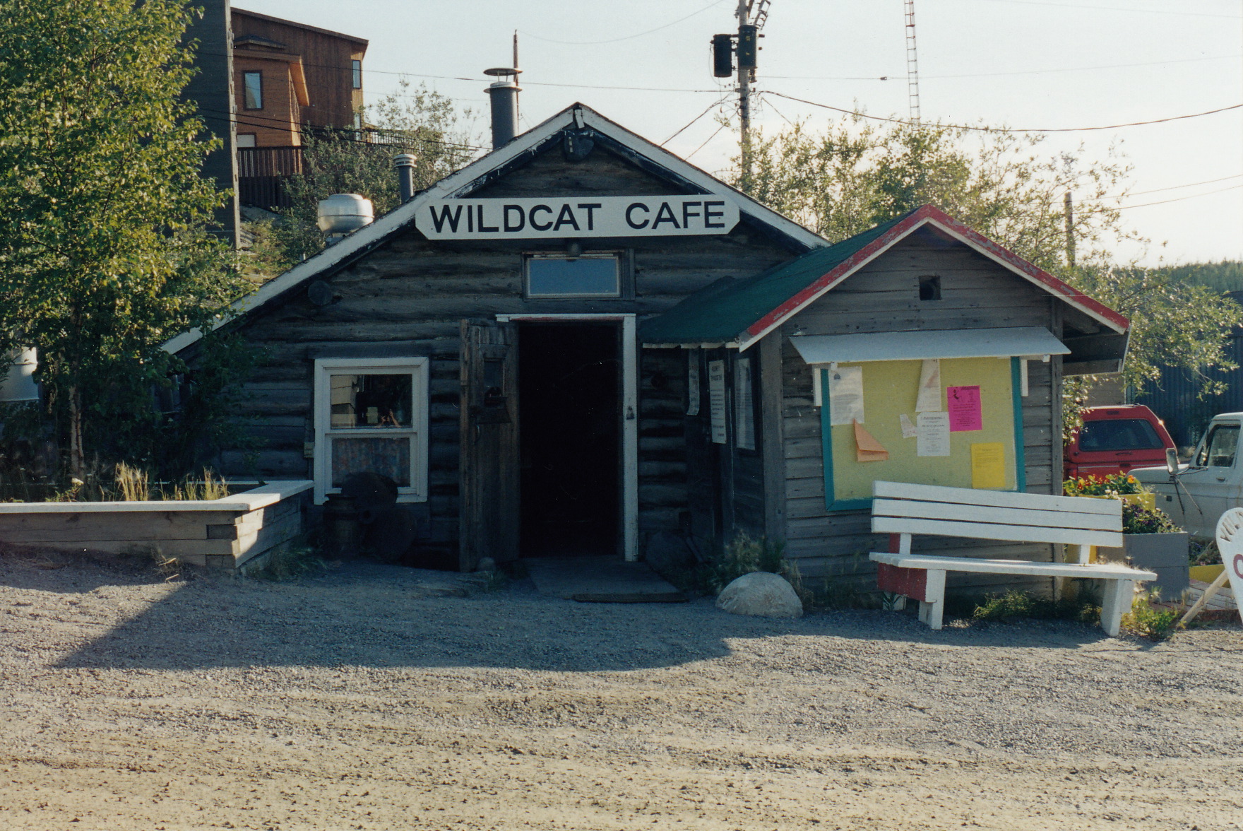
The Wildcat Cafe is one of the original buildings from the early Yellowknife settlement. They served regular bistro food plus some local favorites such as the musk ox and the Arctic Char.

wild cat cafe info

The Wildcat Cafe was along Ragged Ass Road, which was truly the name of the road. We bought one of their roadsigns at the Highway department. They said they took to making them and selling them to tourists to keep them from being stolen all the time. There were signs on the signposts telling people they could buy one of the signs at the Highway office to try to keep down the theft.

2013-04-18 13.58.34

A word about the fish of the far-north waters called Arctic Char. It is like a cross between trout and Alaska salmon. We found a meat market in town that carried fresh Arctic Char and bought a fresh fillet of it. We took it back to our campsite and grilled it on our small charcoal grill. It was fantastic!

arctic char

The campground we stayed in just outside of Yellowknife actually had a small laundry facility. We were very happy to find this available. The campground was beautiful – set amongst the massive basalt of the Pre-Cambrian shield.

campground

We had a lovely site, although it wasn’t completely level.

yellow campsite

We made do with it and Paul got us in pretty good shape with some of our leveling blocks placed under the low side.

While at the laundry building, we met a young man, who with his girlfriend on back, had ridden a motorcycle all the way up to Yellowknife from Miami, Florida. That is 3940 miles!! One way!! He had just put his girlfriend on a plane to fly back to Miami. She wasn’t up to doing the return trip. They had been camping the whole way. I can’t even imagine! I’d love to know if that was the end of that relationship, or just a beginning?

The next day we went over to explore the Yellowknife Golf and Country Club.

golf club

Too bad we didn’t have our clubs with us! This was the golf course from hell, however. The fairways are all sand and gravel, but they have real greens – of a sort. Everyone carries a foot-square piece of Astroturf clipped to their bag to put under their ball to hit it.

astro turf

Winter rules are in effect all year long and there is no penalty if a Raven picks up your ball and carries it off. This happens all the time. For some reason, Ravens like golf balls and they steal them whenever they get the chance.

Here is a photo of the club rules.

club rules close up

Here is a shot of one of the fairways.

fairway sand

See? I told you. It’s really sand and gravel Below is a photo of the first tee box. It is made of artificial turf.

first tee

This club was hopping, let me tell you. I don’t think we could have gotten on the course even if we had our clubs with us. People were teeing off continuously the whole time we were visiting there. This club claimed to be the farthest north golf club in the world. We couldn’t argue with them.

We spent time touring around just looking at the city. The surrounding lake and inlets are gorgeous. There were many pricey sailboats and yachts in their marina and out on the lake. Some fishing boats, as well.

Yellowknife boats

Below is a photo of something we found very curious. It is of a 2-story houseboat – one of many we saw tooling around out on the lake. The fact that we saw 2-story houseboats wasn’t unusual. The fact that was unusual, was that people were cruising around in them all over the lake! We never before saw people cruising around lakes or rivers in their houses!

houseboat

Here you can see that the view of downtown Yellowknife shows tall office towers like you would see in any large city anywhere else. The strange thing is that they are just sitting on all this basalt, anchored by enormous pilings drilled into the solid rock.

yellowknife view

When we got back to our camp, we filled in another Province sticker on our “Where We’ve Traveled in Our RV” map on the inside of our RV door.

door map

We spent some time in a few art galleries and gift shops downtown looking at the native northwestern-themed art. The paintings, carvings, and clothing were so unique and beautiful. The artists were very talented and expressed their everyday lives in their work so well. The town of Yellowknife got its name from the color of the knives that the natives made out of copper. People think it came from the gold in the area, but it really came from the use of the native copper in their knives.

Here is a photo of a noted gift shop we visited called Three Bears Gift Shop. It actually had a lot of native art for sale and many far-north souvenirs, as well as some of the local diamond jewelry. Diamond jewelry? In this shop? Who knew?

3 bears chari gift shop

At the time we were in Yellowknife (1999), there were two large active gold mines in the area. These were the town’s major job sources. Geologists had just discovered lots of diamonds in several kimberlite pipes north of the town which was generating a lot of buzz. The prosperity and commerce in the area was poised to take off for the moon. Geologists from all over the world were all over the area looking for diamonds in the oldest exposed rock on earth. The only other area where these features exist is in Australia.

As was predicted at the time we were there in 1999, over the next few years the area did indeed erupt in new diamond mines north of Yellowknife, which are the source of many of today’s gem-quality and industrial-quality diamonds. These diamonds are extra valuable as they are “non-conflict” diamonds, meaning their sale does not contribute to unethical dictators and regimes who abuse workers and human rights.

As a side note, Paul spent some time looking for a replacement spring at several truck and RV repair places and auto parts shops all over Yellowknife. No luck at all. They said if we really needed a spring, they could have one sent up by air from Edmonton but that it would cost about $500 to do that. We decided to risk it and limp back towards Edmonton hoping the ones we had were going to hold up. We were headed that way next anyway.

You’ll need to read the next post to see if we made it

Klondike River Lodge on to Yellowknife

Cleaned up and fueled up, we left the Klondike River Lodge to head southeast down the Klondike Highway to Whitehorse where we’d join up again with the Alcan Highway. We ventured down the Alcan until a turn-off onto the Liard Highway which headed due north towards Yellowknife. A couple more turns onto other roads after that and we would arrive at our next big goal, making it all the way to Yellowknife on the north shore of the Great Slave Lake. Then we would again be back in the Northwest territories. It was over 1700 miles from Klondike River Lodge to Yellowknife. A respectable distance.

The drive down the Klondike Highway was beautiful and had its own challenges. We were back in a forest fire area and the fires were getting closer and closer to the road.

fire far

We were thinking that it looked like we were getting awfully close to the same large fire that had been fought for almost a month. They would only fight it when it got close to populated areas or roads. The rest of the time, they just let it burn until it eventually would burn itself out or a huge rainstorm would put it out. A ways further along, and we were driving past make-shift forestry firefighter’s camps. We watched helicopters hover over lakes, drop hoses and suck up water into a huge bag, then fly over a burning area and drop it on the fire. We watched as some of those large fire bombing planes flew over the fire line and drop their load of red chemicals on the fire. Then we climbed up a hill and around a corner and there was fire now burning on both sides of the road! A large plume of flame was shooting up just off the left side of the highway! There was thick smoke all around us. We drove faster and came to a turnout. We stopped, I jumped out to take a photo or two and we got back in our rig and took off. The vegetation on both sides of the road was burned black and still smoldering.

fire close

We looked around in amazement and disbelief. We couldn’t believe they were letting people drive through a forest fire!

Later, we heard on a local radio station that they closed down the road right after we went past. They had to evacuate a small town plus about 30 campers and RVs from a local campsite off the road. The road closure left people stranded in Dawson City and facing a 1000-mile detour in order to get anywhere south or east. We were so very lucky as were one of the last motorists to get through before the road was closed down. However, it was very surreal actually driving through an active forest fire.

We arrived back in Whitehorse late in the day and all the RV parks were full. One park had a site left in their ‘overflow’ area which they allowed us to use. It had no services but we didn’t need any. We were totally self-contained for all utilities. We ran off of solar energy, and had satellite TV. We had plenty of water on board. They charged us $5.00 dollars for this minimal site and it was way back off the road in some pretty woods.

It was fine, except someone broke into our truck by prying open the passenger side wind wind- God only knows how – and rifled through the truck cab. The only thing they took was a letter addressed to my aunt and our dial-type tire gauge! They DID NOT take my Nikon camera and telephoto lens, a small NIkon point-and-shoot camera, our hand-help two-way radios, nor our CDs or radio, or any other letters I had written to other family members. Too bizarre! We went into town and reported to the Mounties, and they said it was probably just kids out to see what trouble they could make. After that incident, we never left any valuables in the cab of the truck at night even though we were pretty much out in the wilderness most all of the time. We just brought everything into the RV with us at night. While in town, Paul tracked down another trailer leaf spring to have along with us as a spare. We had not been having very good luck with not breaking springs on all the rough roads. Had we only known, we should have bought more than one extra.

We also needed to buy another new truck tire – the ninth tire we bought on the trip so far. I want to point out, that we started with all new tires on both the truck (4) and the trailer (4) when we left Michigan on this summer adventure. And this made tire # 9 we bought – so far – on the trip. We looked for a tire shop that carried heavy-duty truck tires and found one just outside of Whitehorse. There was a large sign on the front of the building that read:

“If it has tires or testicles, you know you are going to have trouble with it.”

I told Paul that it looked like we had come to the right place. Paul also bought parts to re-build our trailer brakes while the shop mounted our new tire. I then took Paul back to our campsite to do that project while I went to a grocery store to re-provision us for the next couple of weeks on the road in the backcountry.

I found a grocery store and pulled into the parking lot and parked behind a large, vintage motorhome that had a big sign mounted across the back that said, “Yep! Its Eddy.” When I got inside the grocery store, I found that all the grocery carts were chained together – each one chained to the one in front of it. Huh? On the handle was a box with a giant key stuck in it and a slot for a quarter. I had never seen anything like that before? I didn’t have a quarter on me so I went up to the customer service counter to get change. I asked them if all the grocery stores in town had this same set-up? She replied that they did. So I took my quarter and went back to set my cart free. Another woman was coming in from the parking lot and offered to give me her cart if I gave her my quarter!!

I exclaimed my puzzlement at having to pay a quarter to use a grocery cart. She explained to me that you paid your quarter to unchain your cart, and then when you brought it back from the parking lot after putting your groceries in your car, you returned your cart to the front of the line and when you pushed your key thingy in the slot of your returned cart, you got your quarter back. Jeez! She told me that, this way, the store didn’t have to hire those ‘cart shepherds’ to round up carts from the parking lot. She said it was also to keep people from stealing the carts. I told her that it seemed to me that if a person was going to steal a grocery cart, they wouldn’t be very deterred by the fact that they’d lose a quarter for not bringing it back! Anyway!

The next day, we continued on down the Alaska Highway toward Watson Lake. The welds the young kid did on our bumper back in Eagle Plaines on the Dempster Highway on our way back down from Inuvik, held most of the way to Watson Lake. We would have to find someone to re-weld it there, as the bumper was falling off the back of the trailer. We had planned to spend the night in Watson lake anyway.

Early the next morning, we found a heavy-equipment welder at a large repair shop who laughed out loud when he saw the welding job that the kid had done on our bumper. He re-welded it back, reinforcing it with some angle-iron he had around. He said he welds at least one of those a day for people traveling the Alaska Highway. There were some other RV’ers hanging around his shop. One young couple, in their thirties we guessed, had been there for over a week as they needed their entire transmission replaced on their motorhome. They said they were playing on the local softball team to pass the time as their new transmission needed to be trucked in from somewhere down in the lower 48, which was going to take at least another couple weeks. Another couple, about 10 years older that we were, had been there for a month as they were waiting for a whole new engine for their motorhome. We were beginning to feel very lucky to have the minor troubles we had.

We left Watson Lake and continued on toward our turn-off to the Liard Highway. The scenery was just gorgeous along the next 300-mile stretch of the Alcan. This stretch is a far-northern extension of the Rocky Mountains.

5 fing rpaids

5 fin rapids2

Next we stopped at the famous Liard Hot Springs.

Liard springs sign

We changed into our swimsuits and grabbed towels and prepared to hike back to the springs. They are really beautifully maintained by the Provincial Park System – the Canadian equivalent of our National Park Service in the United States, so people can use them safely.

hot springs1

There were wooded decks and stairs and walkways all maintained by the Canadian National Parks system.

hot springs joanie

We thoroughly enjoyed our stop here. The water was EXTREMELY hot – boiling in fact, where it first came up out of the ground. You could control how much heat you could endure by going further down the boardwalk away from the boiling river. It was very refreshing – a natural hot tub.

hot springs2

We hiked back to our RV, being very careful to watch for bears, and we took a shower and got dressed back into our traveling clothes. The bears around the hot springs have been known to set upon tourists as some stupid people have fed them trying to get a better close-up photo. It has trained them to be aggressive and menacing. They periodically have to trap the bears and move them hundreds of miles away into the interior and kill them if they make their way back.

Further along the road we saw many Stone Sheep along the sides of the road.

stone sheep close

Stone sheep

Stone ram

stone sheep close

We couldn’t for the life of us figure out what these sheep were eating – grazing in the gravel along the edge of the road. Maybe that’s why they were called Stone Sheep???? We also saw a large black bear but he wasn’t in a good place to get a photo.

Our Liard Highway turn-off came just before we got to the town of Fort Nelson, but we decided to go into Fort Nelson and then come back for our turn as we needed to have ANOTHER tire repaired. We then doubled back and got onto the Liard Highway.

Liard Trail sign

Liard trail distance sign

We drove to a campsite north about 100 miles up the road at a community named Fort Liard.

Liard campsite

Right after we stopped in this idyllic site, I was starting dinner and Paul was setting us up for the night. He came in and told me that we had another broken spring. I burst into tears. I usually don’t do that. So I fixed myself a Pimms and soda drink and made us a spicy curry for dinner. We were, of course, in the middle-of-nowhere, 100 miles from a paved road. Paul assured me he would replace it in the morning with the spare spring he had fortuitously purchased back in Whitehorse. No problem.

So the next morning, on the shores of this pristine little lake, Paul began replacing another broken spring. I reclined on our couch with the dog and read a romance novel. By 11 AM, we were again on our way to drive as far as we could get before it was time to stop for the night again. We kept reassuring ourselves and each other that it was only 300 more miles of gravel and we’d be back on a paved road – home free. Why was this not particularly reassuring?

We got to a beautiful campground called Sambaa Deh Falls Park. It was about halfway between where we turned eastward off of the Liard highway onto the Mackenzie Highway, and where we would again be on paved road at Hay River, on the south shore of the Great Slave Lake.

Sambaa Deh Falls sign

The little park headquarters was very cute.

park office

How cool is this place? It is only another 80 miles of gravel from here and the rangers were very friendly and told us to enjoy the scenery of the falls, but to be very careful because the ground around them was unstable and if you fell in, you’d be dead. They said there were no warning signs nor guard rails like we were used to seeing at hazardous attractions in the United States.

campsite

This was our campsite which was clear and open – an easy in and out.

falls1

There was no way to photograph these falls to capture either the fierceness or grandeur of them. They roared with such fury and intensity that you could barely hear someone speak even if they were shouting right next to you. We came to a fresh makeshift memorial along the edge.

falls memorial

From this angle (we were NOT going any closer) the falls just look like a rushing stream, but there was a precipitous drop-off into them and they were very deep and powerful. It was eeire because clearly someone died here. If you look closely, you can see stones and flowers laid out in the rough shape of a cross.

We went back to the ranger station and asked them what happened. They showed us a newspaper article about a young man and his brothers on their way from a village near Fort Simpson over to a music festival in Yellowknife. They stopped here for a break and to walk along the falls. The one brother got too close and fell in and was swept away by the powerful water which plunged over a 200 foot limestone cliff, then plunged over another cliff into the Mackenzie River in a deep canyon below.

His brothers and the park service and many friends and relatives searched for him for weeks afterwards and only found a few pieces of his shredded clothing. It was very sad. They recently gave up the search and erected the stone cross with the flowers.

We went back to our RV and I began heating up left-over curry for dinner. Paul came inside and told me that we had another broken spring. He assured me that he could build a new spring using the unbroken leaves from the old springs we still had with us, and that we could surely make it to Yellowknife where he could buy another spare spring. I am beyond crying. So I fixed us a Happy Hour while our curry reheated and we decided to just enjoy this beautiful, though sad, place. Tomorrow would just have to take care of itself. We’d deal with the broken springs issue when we got Yellowknife.